Member states at the United Nations overwhelmingly voted to adopt the "Correct the Map" resolution, a campaign spearheaded by African nations and the African Union to replace outdated cartography.
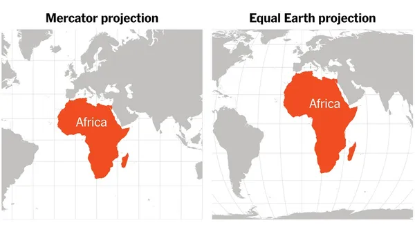
The approved resolution encourages governments, educational systems, and digital platforms to transition away from the traditional Mercator map and embrace equal-area projections like the Equal Earth model. While the older 16th-century map artificially balloons northern regions like North America and Europe while compressing equatorial landmasses, the corrected projection reveals that Africa is actually fourteen times larger than Greenland.
How It Happened
Togo introduced the resolution on behalf of the African Group at the United Nations, mobilizing months of intense diplomatic pressure to correct a glaring geographic bias. Generations of students grew up viewing a flawed global representation designed primarily to assist European maritime navigation, which inadvertently baked a profound psychological shrinkage of Africa into international consciousness.
One hundred and sixty-four member states voted in favor of the correction, securing an overwhelming global consensus despite pushback from Western detractors. By establishing scientific reality over historical distortion, the international community opened the door to modernizing school textbooks, newsrooms, and digital applications. The move forces global institutions to confront the subtle ways visual propaganda shapes economic investment, political respect, and international development priorities.
Why it Matters
Redrawing global maps to show Africa at its true scale is not just about geography, but about shattering the mental chains of cartographic colonialism that taught generations to view the continent as an afterthought. When international frameworks rely on visual tools that minimize African landmass, they reinforce systemic biases that bleed into trade, aid, and global governance. True continental empowerment starts with refusing to accept any system that draws Africa smaller than it actually is.